Download PDF Here:
Posted in Boating Gear, Boating Resources, Gear, Innovations, iPhone App, sailing, Technology, Yachting |
The following courtesy of: http://www.theguardian.com/world/2014/sep/20/two-britons-missing-yacht-mexican-hurricane
The BBC reported the couple were Paul Whitehouse, from Wolverhampton, and Simone Wood, from London, both in their 40s.
The two were reported missing aboard a yacht in the Sea of Cortez on Friday, and Mexican marines and sailors were taking part in a search operation.
Their yacht was one of 25 that capsized in the hurricane, the BBC said. It is thought Whitehouse worked as a scuba instructor in the city of La Paz.
A spokeswoman for the Foreign Office said: “We are in touch with the local authorities and are providing consular assistance to the families at this difficult time.”
The British embassy in Mexico has advised British nationals in those areas of Baja California and Baja California Sur affected by the hurricane to leave through Los Cabos international airport.
A spokesman for the embassy told the BBC: “We are urgently working with authorities on the ground in Mexico to ensure the safety of British nationals following hurricane Odile, and have sent staff from our embassy to assist in this.”
The hurricane affected power and water supplies, as well as phone services, triggering widespread looting. Three other people, a German and two South Koreans, are known to have died.
Power has been restored to about one-fifth of customers in the resort cities of Los Cabos, with 200 electricity workers dispatched to the area.
Unfortunately, Simone was found dead in the mangroves yesterday. The most complete information I’ve found is collected on the Charlie’s Charts Facebook page from a variety of sources, including the radio nets.
http://www.facebook.com/CharliesCharts.
For anyone who wishes to donate, Club Cruceros de La Paz has set up a donation site: http://www.gofundme.com/en7dtw. I was a member of Club Cruceros when we were in that area and saw the work they do to coordinate the work during disasters. I trust them to do
well with the money collected, both for those who lost boats and the volunteers who are actually doing the work (there’s no such thing as SeaTow, it’s all volunteers to get the boats off the beaches/rocks/mangroves and remove the navigation hazards).
Carolyn Shearlock
TheBoatGalley.com <http://theboatgalley.com/> & The Boat Galley Cookbook
Posted in disappearance, missing sailor, Safety & Security, sailing, Vessel Lost, weather | Tagged baja, bbc, british, embassy, hurricane, la paz, london, Mexico, odie | 1 Comment »
Here’s the latest courtesy of ‘Lectronic Latitude (Latitude 38):
September 17, 2014 – Cabo, La Paz, Puerto Escondido & San Carlos
 This boat was one of several boats that were beached in San Carlos by Odile. Nearly two dozen boats sank or went ashore at La Paz. © 2014 Jim Cochran |
The biggest — and worst — news is that there apparently is no new info on the status of three sailors that are reportedly missing from boats in the La Paz anchorage: The young Mexican man named Gabriel on a steel boat is reported fine. But Holly Scott of Charlie’s Charts reports that the Mexican Navy dove on the sailboat Princess, owned by a man named Gunther, and didn’t find any sign of him or his dog. Paul and Simone of Tabasco II have not been found either.
The following is a collection of information we’ve come across about the hurricane damage in the last two days, including the first reports of damage to boats on the mainland side. It’s more jumbled than we’d like, but it’s the best we can do given the circumstances. We try to give credit in all cases, but sometimes info has been forwarded multiple times without the original source of the info being included. Yesterday we omitted giving Holly Scott credit for a chunk of our report. Our sincere apologies. Holly is a longtime good friend of Latitude and has been doing a great job of getting information out of Baja.
Cabo San Lucas — It’s our understanding that the Cabo Marina infrastructure and boats within it generally did better than the rest of the city, which suffered tremendous damage. Getting the airport back in full operation is going to be critical for two reasons: 1) getting critical supplies to the resident population, and 2) getting trapped tourists back home. That said, several news agencies reported this morning that military transports are currently flying hundreds of tourists out to gateways on the mainland. As expected, roads in Southern Baja, have been badly damaged and fuel is in very short supply. There has been looting at Costco and other stores, but these people are cut off from the world and are in desperate need of water and food. Particularly water, as it’s hot and dry in Cabo.
 Most of Cabo is in very rough shape. But despite the small boat damage seen here, reports are that no yachts in the marina suffered significant damage. © 2014 The Vette Barn |
The following are some details from Mark Drewelow of YachtAid Global, which arranges for megayachts to provide humanitarian aid for coastal communities around the world:
“At 1730 today (Monday) Cabo time I spoke with local Superyacht Agent Victor Barreda. He weathered Odile at home, and he and his wife and kids are okay. He says the town has no electricity and it looks like every building has been damaged. If electricity doesn’t come back on, fresh water becomes a major issue quickly. Yacht Aid Global has one 75-meter superyacht that will be deeply involved in an immediate relief effort, focusing on producing 4,000 gallons a day of fresh water for locals.”
Drewelow spoke with the marina managers at Cabo and they reported that the boats in the marina and the marina itself came out “unscathed.” Mike at Driscoll Boat Yard spoke with the owner of a large motor yacht. He said there was some very minor damage to his boat, but all in all, the boats in the main part of the marina did remarkably well. Photos show that the small boats on the port side entering the harbor took a beating.
“Every yacht big or small that intends to head south to Cabo needs to bring aid,” Drewelow said. “Recovery will take months. YachtAid Global is coordinating some efforts with Marine Group Boat Works, which also has a facility in Cabo San Lucas. The Marine Group Boat Works yard in Chula Vista is collecting items that are of critical immediate need: drinking water, basic first-aid stuff, food with a long shelf life, temporary shelters, small line. If you want to help, contact Leah Yam, Cabo Relief, at Marine Group Boat Works in Chula Vista at (619) 427-6767. You can also donate funds via YachtAid Global’s donation page.”
La Paz — Again, the most urgent matter in La Paz, homeport for hundreds of cruisers, is that the three cruisers named above are still missing. Beyond that, boats in the various marinas apparently suffered very little if any damage, while some boats on stands at Atalanta Dry Storage, adjacent to Marina Palmira, suffered damage. Bob Davis of the Shell Beach-based Irwin 44 Nirvana called the Latitude offices this morning by satphone and reported that 22-25 boats had broken free in the cruiser anchorage in front of town. Five sank and the others were washed ashore on the Mogote peninsula or into the mangroves. We hope to have a complete list in our next posting. Davis reports that there was no real damage to boats in either of the La Paz boatyards. He says also that the Mexican navy has been conducting ongoing search and rescue (SAR) operations since shortly after the storm, and that the cruising community has pulled together in an impressive effort, in some cases refloating beached boats.
It’s been widely reported that Internet and phone service are still out in La Paz, so lots of family and friends back home are desperate for word that loved ones are fine. Authorities stated that electricity is available in only 17% of the city, but they are hopeful that it will be completely restored by next week. Davis was told that the fiber-optic cable that runs from Cabo all the way up the Baja Peninsula had been severed, leading to grim projections on the timetable for re-establishing phone and Internet service. But before our satphone conversation ended, his wife Sherry suddenly got a TelCel connection on her cell. We are now told that telephone and Internet connections seem to be working well including major land line connections. Davis witnessed “an armada” of electrical service trucks arriving recently from the mainland by ferry to address electrical issues in Cabo and La Paz.
 Looking northwest from just outside the entrance to Cabo’s yacht harbor damage is strewn all along the shore. But being constructed with steel-reinforced concrete, we imagine that most structures are still standing, although damaged. The building in the far right of this image was under construction. © 2014 Whitney Roe |
The La Paz Airport isn’t yet functional, and the TransPeninsula Highway may be destroyed in several areas. However, Davis has been able to confirm that the highway is fully functional from Puerto Escondido to Mulege. Vessels have been arriving from the mainland with aid for Southern Baja, and President Pena-Nieto is said to have toured the area by helicopter.
According to Bob Davis, consensus among La Paz cruisers is that Cabo is in much worse shape than La Paz, where some stores — including Walmart — are open, although all banks are closed. He has not seen any TV coverage, but the word-of-mouth info he has gathered about desperate people looting stores in Cabo for food and water is in sync with various network TV broadcasts.
In an earlier message relayed by Holly Scott, Davis wrote: “Susan Ross of the Portland-based Endeavor 43 Two Can Play suggested that the Baja Ha-Ha fleet could potentially provide an essential service by transporting ‘stuff’ [supplies, medicines, etc.] down to Southern Baja when the fleet comes south, and to the Turtle Bay and Mag Bay regions. Granted, early November is a ways off, but based on what I am hearing regarding Cabo, it may still be in ragged shape at that time.”
We’re certain that members of the Ha-Ha fleet would be happy to do all that they can. However, with the fleet’s arrival being almost two months away, we’ll have to see how things play out. People have to also remember that even one small ship could carry far more than the entire Ha-Ha fleet, but we’ll stand ready to help.
From Lewis Stewart Keizer: “The dry storage boat yard adjacent to Marina Palmira has a number of toppled, damaged, crushed or dismasted boats. All the other marinas had spotty but manageable damage (cleats ripped off docks, etc.) I know of no boats in marinas that sustained any appreciable damage, short of one boat in Marina de La Paz with a wooden mast that broke during the storm.
“Two Baja ferries unloaded a massive number of military and mostly CFE — the equivalent of PG&E — trucks, all of which is it rumored are headed to Cabo. Cabo is in really bad shape. The word down here is that Cabo airport will not reopen until the 21st. La Paz airport won’t reopen for a few days, but info is non-specific.
“Several of the 20 or so beached boats have been refloated this afternoon. A number of others are scattered hither and yon, and will be refloated as manpower, tow power and tides permit. A military flight is airlifting a number of stranded civilians out of La Paz to Mexico City today. Don’t know who they are.”
In a Tuesday-afternoon update from Nirvana via Holly Scott, Bob and Sherry made this offer: “Bercovich boatyard and boats on the hard had NO damage. I walked through there this morning and everything is intact. . . If anyone wants me to go down there and look at a specific boat, let me know and I will. Abaroa boatyard had some damage but again, I’ve not heard of any specific vessel damage in the yard. Same story, give me a vessel name and I’ll get the specifics. Atlantic boatyard nearby Marina Palmira took a real hit: a number of boats toppled over, some stacked on others, some crushed.”
Puerto Escondido — From Jake Howard aboard the Hunter 45 Jake in Puerto Escondido on Wednesday morning: “Here is the best list I can put together at this time. Firefly is here. They were right behind us in the storm and they are OK.
BOATS BEACHED IN THE MAIN ANCHORAGE:
BOATS IN THE WAITING ROOM OR API AREA:
One other boat was dismasted but don’t know name. Unoccupied. Should be Salvageable.
That’s it, I think. FYI – Heard on Amigo Net this morning that Pantera and Bob are OK in Santa Rosalia. Lot of damage there. Old marina destroyed. All but one boat on that dock beached or sunk. Town is awash in mud.”
San Carlos / Guaymas — John Skoriak reports: “As more photos are posted on San Carlos message boards, the damage from Odile becomes evident. It seems that three large sailboats — one trimaran and two monohulls — broke loose from their moorings. Apparently all the boats at the two marinas are fine, and the same is true at the Marina Seca Dry Storage area where I have a Catalina 36.
 Now reduced to a pile of rubble on the San Carlos shore, this was once a large trimaran. © 2014 Vince Radish / Viva San Carlos Message Board |
The boat in the first photo in today’s report, apparently taken by Jim Cochran of the San Carlos-based Bliss, broke free from her mooring and grounded on the beach at the end of the San Carlos Bahia anchorage, “which is actually one of the best and most protected natural deepwater anchorages in Mexico,” says Skoriak, “except, of course, in a hurricane from south.”
The following is the firsthand report, from Monday, by Jeff Hartjoy of the Baba 30 Sailors’ Run in the northern Sea of Cortez, who is preparing for a nonstop sail around the world via the Southern Ocean:
“I figured out where the hurricane was when the eye passed over at 1:30 p.m. It was calm windwise for 30 minutes, although I had 10-foot waves, and had to sit in the trough and roll like a baby in a box car. My ice-maker flipped upside down and the cushions were all falling all over the place, but I was happy as the wind had quieted. After 30 minutes, the wind came back with a vengeance and blew like stink. The good thing was it had shifted 90 degrees, putting me once again in the protection of the land. The wind was also beating the 10-foot waves down to where they were about four feet. If my anchors let go, it looked like I could escape. Previously, I would have had to dive over the side before the boat crashed ashore and swim for my life.
“The worst part of the first half was I was having gusts to 85 knots. They would last about 15 seconds, and heel the boat so far that the rail was in the water. A couple of times I was tending to things on deck, and the rain was like buckshot. It stung! I couldn’t see anything, as the wind was like smoke on green water. So far, the only thing that is damaged is the bimini, as the zipper started blowing apart. So I rolled it up. One of the solar panels was trying to blow off the boat, and I had to tie it down with a rope and black tape. I think this thing will be gone by 7:30 p.m. tonight, and the back half of a hurricane is usually lighter than the front half’.”
Posted in boating, boating blogs, Cruising On A Cat, disappearance, missing sailor, Safety & Security, Ship Wreck, Vessel Lost, weather | Tagged baja, hurricane odile, Mexico, missing cruisers | 4 Comments »
 Photo by Nancy Birnbaum © 2014 FORT LAUDERDALE, Fla. (August 28, 2014) – Entering its 55th year, the Fort Lauderdale International Boat Show® (FLIBS), the largest in-water boat show in the world, is set to take place from Oct. 30 through Nov. 3, attracting an international audience of thousands of marine enthusiasts to the “Yachting Capital of the World” to experience the single best showcase of marine products and accessories on the planet. Each year, show organizers strive to deliver new, exciting features to enrich the overall show experience and engage audiences.Here are the top 13 things to see and do at this year’s show: 1. Check out an astounding number of yachts. From astonishing super-yachts to fishing boats, runabouts and boats for every budget, the Fort Lauderdale International Boat Show delivers the excitement of boating for anyone who loves to get out on the water. 2. Stop by Pier 66 Marina, the show’s newest location. Recently reopened following a total marina renovation, this show site will feature an impressive display of brokerage yachts and attractive dining options, including Pelican Landing restaurant for casual dining and drinks, and fine cuisine at the upscale Grille 66 & Bar. Pier 66 Marina will be accessible via shuttle bus (Green Line) and/or Water Taxi. Qualified guests will be able to sea trial yachts during the show from this location. 3. Grab a bite to eat at the show’s new, full-service pop-up restaurant, Hugh’s Café at the Hall of Fame Marina, operated by Hugh’s Culinary. Located at the Hall of Fame Marina show location, the concept is designed to offer another quality dining option for guests and a place for industry professionals to meet and conduct business. 4. Relax and grab a drink at the new IGFA Sportfishing Lounge, located inside the Broward County Convention Center. While you’re there, enjoy free fishing, diving and boating seminars and workshops for anglerstaught by some of the area’s best captains and professional anglers.  Photo by Nancy Birnbaum © 2014 5. For the kids, catch the Hook The Future kids’ fishing clinics where kids get a free rod/reel combo and plenty of other prizes. 6. Check out the expanded Blue Wild area featuring scuba and freediving, lobstering and safety seminars, a huge selection of marine art and the all-new JYPSEA Swimwear Show. 7. Take in a flick at the Boat Show Film Festival,screening Crew Unlimited’s Yachtie Da Film Festival, Guy Harvey Ocean Conservancy films, and trailers from this year’s Fort Lauderdale International Film Festival. 8. Check out live paddleboard, kayak, hovercraft and freedive demos at the AquaZone, presented by Nautical Ventures and new this year to the Sailfish Pavilion at the Convention Center location. Guests will learn directly from the pros in a 25-foot-by-50-foot, 15,000 gallon pool. 9. Ogle the exotic auto display, a private jet, personal submarines and the latest yacht and water toys. Even if you’re not in the market for a new boat this year, the show offers amazing exhibits and fun for all. 10. People-watch at the show’s world-famous floating cocktail lounges. Find a seat, grab a cold drink and cool off in the shade. Have a bite to eat and recharge while enjoying live music and even livelier crowds. 11. Explore the impressive displays and shop for the latest gear or gifts. Nearly $4 billion worth of boats and marine products across more than three million square feet of exhibit space includes an array nautical clothing, gear, the latest marine electronics, accessories and more. 12. Hop a ride to the show aboard free riverboats and $10 all-day Water Taxi transportation. The show’s seven locations are connected by a convenient land and water transportation network offering several parking and transportation options to get show-goers to the Bahia Mar Fort Lauderdale Beach Hotel & Yachting Center, the Hall of Fame Marina, Las Olas Municipal Marina, Hilton Fort Lauderdale Marina, Sails Marina, Pier 66 Marina and the Greater Fort Lauderdale/Broward County Convention Center. 13. Watch the spectacular fireworks display on opening night at the Bahia Mar Marina. FLIBS always wows guests in many ways, whether it is the jaw-dropping superyachts, the lavish parties and fun-filled events or the amazing fireworks. Year after year, the show aims to bring an enhanced experience to all who come through the gates.  Photo by Nancy Birnbaum © 2014  Photo by Nancy Birnbaum © 2014 |
|
SCHEDULE:
ADMISSION:
The Fort Lauderdale International Boat Show® is owned and sponsored by the Marine Industries Association of South Florida, managed and produced by Show Management and sponsored by Gosling’s Rum, Taiwan External Trade Development Council (TAITRA), GEICO, YACHTS International Magazine, AIM Marine Group, Budweiser, BoatShowHotels.com, BoatQuest.com, Palm Harbor Marina, Smallwoods Yachtwear, International Game Fish Association (IGFA), Monte Carlo Vodka and the South Florida Sun Sentinel.
|
Posted in boating, Boating Gear, Boating Resources, Boats for Sale, Marine Industry, Press Release, Travel & Leisure, Yachting | Tagged boatshow, FLIBS, fort lauderdale, sportfishing | 2 Comments »
Posted in apps, boating, boating blogs, Boating Gear, Boating Resources, Boats for Sale, Cruising Resources, Green Gear, iPad, iPhone App, sailing, Technology, weather, Yachting | Tagged boat gear, burger boats, iphone, weather, weatherflow, windmeter, Yachting | 1 Comment »

Image courtesy of worldcruising.com.
The news came today from the team at World Cruising Club of the death of Steve Black, founder of the Caribbean 1500 rally, following a long personal battle against cancer. We are all saddened by his passing and our thoughts are with his family.
The WCC Blog wrote. “Steve was an inspiration to very many sailors through his long and varied career in sailing, including numerous offshore races, many of which were single-handed, and a three-year stint as executive director of the U.S. Sailing Association, based in Newport, Rhode Island. However, there is no doubt that his biggest legacy will be the Caribbean 1500 cruising rally, which first set sail in 1990, with a fleet of 50 cruising boats to make landfall in Virgin Gorda, British Virgin Islands.
The impetus for the rally started when Steve saw that cruising sailors outnumbered offshore racing sailors, but there were virtually no organized events for cruisers. The Caribbean 1500 rally offered the chance to sail in company, combined with preparatory seminars taught by sailing experts, an SSB radio safety net at sea, and of course a great deal of fun and socializing. Always leading from the front, Steve sailed with the rally, helping to inspire and trouble-shoot the fleet at sea.
He always found time to foster personal connections, spending hours matching crew to boats, allowing those new to sailing to take experienced crew along, or placing novices onto boats with veteran skippers for mile-building. His calm manner and easygoing personality led to many firm friendships being formed over the years.”
Born in St. Louis, Missouri, Black moved to Michigan where he ran an educational publishing company. He started sailing recreationally in his mid-30s in regattas hosted by the Grand Haven Sailing Club. Black learned the sport from single-handers and has always preferred this aspect of sailing.
“Steve is the reason I’m doing what I’m doing today,” says Andy Schell, event manager for the ARC Caribbean 1500 and offshore delivery skipper. “He put me on a 1500 boat back in 2006, which was my first offshore passage, and helped me make connections in the ocean sailing world. Steve was a huge inspiration. It’s an honor to be managing the 25th Caribbean 1500 this year and carry his legacy into the future.”
After helping make offshore cruising more accessible to countless cruisers since the early 1990s, Steve Black, sold out to the World Cruising Club (organizers of the popular Atlantic Rally for Cruisers, among others) in 2011.
When Steve announced his decision to retire in 2010, he was determined that “the 1500” would continue and develop into the future. It was his firm belief that after 21 years of his leadership, combining the Caribbean 1500 with World Cruising Club’s world-wide portfolio of rallies would see it continue to inspire sailors for many years to come.
“The most satisfying aspects of starting the Caribbean 1500 Rally and other rallies such as the Atlantic Cup and now the Bahamas Cruising Rally, said Black in a 2010 interview with All at Sea, “are the friendships formed. “We had 235 past ralliers meet at a reunion at the Annapolis Boat Show this year.”
The 2014 Caribbean 1500 rally will be the 25th edition and a fitting memorial to a man who encouraged so many cruisers to discover the delights offshore sailing.
Posted in adventure Sailing, blogging, boating, Cruising On A Cat, Cruising Resources, offshore sailing, Yachting | Tagged caribbean 1500, cruising rally, steve black, world cruising club | Leave a Comment »
It’s over 70 years old, a thin magenta-colored line appearing on over 50 different navigational charts covering the Atlantic Coast and Gulf, snaking along the route of the Intracoastal Waterway. Now, thanks to NOAA’s Office of Coast Survey and a public-private partnership with Active Captain, an interactive cruising guidebook, NOAA will be updating the “magenta line” on all of its newly-issued navigational charts to help keep boaters in safe waters. Boat Owners Association of The United States (BoatUS) submitted comments on the proposal to NOAA, who had initially proposed removing the line entirely. However, responding to BoatUS’ and other boaters’ comments, NOAA will tap into users of Active Captain to update the route in an on-going effort that will benefit the boating community.

The thin magenta colored line marking the Intracoastal Waterway is like a yellow brick road for boaters transiting the East and Gulf Coasts. Credit: Boat US
Boaters may contribute to the updating effort by joining Active Captain at www.activecaptain.com.
Jeffrey Siegel, owner of ActiveCaptain said in his recent newsletter, “In September 2013, US/NOAA began asking boaters for feedback on the “magenta line” – the magenta colored overlay on US charts showing the recommended route of travel for the various US intracoastal waterways: New Jersey, Atlantic, Dismal Swamp, Florida West Coast, Gulf West, Gulf East, Okeechobee Lake, and Okeechobee Rim. The line first appeared in 1912, saw a major update in 1935, with only rare updates since then. This has caused many tense moments as the real channel has shifted away from the marked channel leaving boaters confused about the correct path. ActiveCaptain hazard markers have helped with those, “what do I do here?” moments.
The feedback from boaters was heard loud and clear by NOAA. They claim that 99.9% requested that NOAA maintain the magenta line rather than remove it.
How will they go about fixing the magenta line?
That was part 2 of the NOAA Coast Survey announcement. They have added ActiveCaptain to their “cartographic toolkit in the chart evaluation system.” Last year NOAA licensed the ActiveCaptain data for internal use. We wrote some custom software to make it easier for the cartographers to use the hazard data you provide to help update charts and fix the magenta line. The first part of the software has been delivered to NOAA for their use.
NOAA approached us because they were already using the hazard data to locate problems but had to manually search on areas of interest to see what needed attention. Now hazard changes are automatically presented to them so they can quickly go through the changes and determine whether additional surveys or chart changes are needed.”
Posted in boating, Cruising Resources, Newsworthy, Safety & Security, sailing, Technology | Tagged activecaptain, charting, magenta line, Navigation, noaa |
Choosing the right navigation app is no easy feat. Some cost a few precious boat bucks just to download, and “free” doesn’t necessarily mean 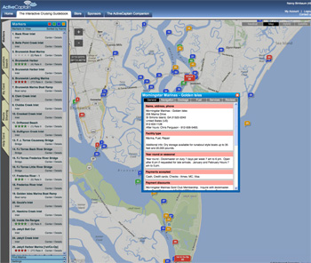 “less” when it comes to features. With the recent news that NOAA will stop printing paper charts this April, iPads are fast replacing chart plotters on the bridge or in the cockpit.
As a former cruiser, I often relied on print cruising guides to learn about a new port or cruising area. As we all know, this kind of information is always in flux. And there’s the rub: How do we get the latest information, preferably from other cruisers? The answer: AC.
For the past few years ActiveCaptain (AC) has grown and expanded to include over 100,000 boaters who write reviews and updates on anchorages, ports, hazards, facilities and more, all around the world.
Sail with confidence with any of the five navigation apps below. They all include ActiveCaptain data as an overlay for members. (AC membership is free).
![]() The newest offering in the Apps Store is Skipper and the free version isn’t just a trial; it includes a handy NOAA online chart viewer for onshore planning and satellite imagery on shore. For the Pro version you pay an annual fee of $12/year and you don’t have to pay extra for the charts you’ve already paid the Government for in taxes. NOAA Charts are auto-updated (or choose Google Earth or Topo maps, including historic topos. What fun!). All is cached and displayed offline very seamlessly, except weather and Google Earth requires an online connection. It also does routes/waypoints and real-time navigation (which Garmin’s app doesn’t do). Your subscription syncs your personal data and routes, waypoints, tracks, etc. between your multiple devices. Raster charts (the best!) load fast and look great since they are mosaic-ed together and are only 1.8GB each for the smallest possible download size. Skipper’s creator, Andrew Johnson says that Inland Rivers Charts including all NOAA vector charts will be added soon and he is working on ways to integrate Open Street Map technology. Perhaps my dream of having one app that shows both Charts and Maps may soon become real!
The newest offering in the Apps Store is Skipper and the free version isn’t just a trial; it includes a handy NOAA online chart viewer for onshore planning and satellite imagery on shore. For the Pro version you pay an annual fee of $12/year and you don’t have to pay extra for the charts you’ve already paid the Government for in taxes. NOAA Charts are auto-updated (or choose Google Earth or Topo maps, including historic topos. What fun!). All is cached and displayed offline very seamlessly, except weather and Google Earth requires an online connection. It also does routes/waypoints and real-time navigation (which Garmin’s app doesn’t do). Your subscription syncs your personal data and routes, waypoints, tracks, etc. between your multiple devices. Raster charts (the best!) load fast and look great since they are mosaic-ed together and are only 1.8GB each for the smallest possible download size. Skipper’s creator, Andrew Johnson says that Inland Rivers Charts including all NOAA vector charts will be added soon and he is working on ways to integrate Open Street Map technology. Perhaps my dream of having one app that shows both Charts and Maps may soon become real!
BlueChart uses vector charts with features such as search, routes, waypoints, weather stations (choose conditions overlay showing dew points, temperatures, wind direction and speed, water temp, visibility) GRIB weather with wave heights and period, celestial data, measuring feature, real-time tracking. Each icon gives great details when tapped. Lots of overlay features can clutter up the chart but choosing which ones to view is easy using the cool “radial chart object menu”.

The first full resolution, seamless charting iPad app. Charts&Tides uses NOAA and CHS vector cartography. Covers all of U.S. and Canada and cost $20-$40. New features include AIS support, Closest Point of Approach (CPA) computations and alerts, more connectivity options for GPS (WiFi, GPSD), new Dead Reckoning Mode and interface improvements.
*This just in… Now you don’t have to open a different app to chart a new area of the world. Navimatics has just added a newly developed chart engine to Charts & Tides for iOS and for Mac computers. Now the app is free and you can add these two options:
– The entire US NOAA collection of charts: $19.99
– The entire US NOAA collection + CHS Canadian charts: $39.99
![]()
From the folks who brought you affordable PC and MacOS charting. Their PolarView MX app for iPhone or iPad offers both vector and raster chart viewing combined with extensive instrument support that many mariners are seeking. Chart coverage includes U.S. and U.K. and world-wide charts are available.
![]() Developed by software engineer/live aboard world cruiser, Mark Hayden. SEAiq uses free NOAA vector charts. Try SEAiq Free first, then upgrade to SEAiq USA or Open for $9.99 with in app purchase to enable all features. SEAiq Open allows you to use your own vector charts. (S-57, S-63, CM93, iENC, BSB, and KAP) or you can purchase charts for anywhere in the world from ChartWorld. Also, with Inland ENC support, you can download hundreds for free charts for many rivers in Europe. Other features: Import/export waypoints and routes. NMEA data, AIS, Track recording, GRIB weather downloads, anchor alarm, instrument data, TCP/IP WiFi NEMA data.
Developed by software engineer/live aboard world cruiser, Mark Hayden. SEAiq uses free NOAA vector charts. Try SEAiq Free first, then upgrade to SEAiq USA or Open for $9.99 with in app purchase to enable all features. SEAiq Open allows you to use your own vector charts. (S-57, S-63, CM93, iENC, BSB, and KAP) or you can purchase charts for anywhere in the world from ChartWorld. Also, with Inland ENC support, you can download hundreds for free charts for many rivers in Europe. Other features: Import/export waypoints and routes. NMEA data, AIS, Track recording, GRIB weather downloads, anchor alarm, instrument data, TCP/IP WiFi NEMA data.
Posted in apps, blogging, Boating Gear, Boating Resources, Cruising On A Cat, iPad, Safety & Security, sailing, Technology, Travel, world cruising, Yachting | Tagged charting, mobile apps, Navigation, water sport | 3 Comments »
My favorite Tall ship cruise line Star Clippers is offering an exciting opportunity for yacht and nautical aficionados in 2014. Star Flyer’s Sept. 27 sailing will feature an overnight call at St. Tropez, France, during the annual Les Voiles de Saint-Tropez international regatta.

Star Flyer undersail. Photo: N. BIrnbaum ©2014
Les Voiles de Saint-Tropez, which began in 1981 as La Nioulargue, attracts modern and classic yachts from across the globe that race for the coveted Rolex Trophy. In 2013 more than 300 boats representing 150 years of naval architecture and aesthetic participated in the event.
“We’re always looking for exclusive events, and the chance to attend Les Voiles de Saint-Tropez is an exciting opportunity for our guests who are largely yachting enthusiasts,” said Mark Carlson, director of marketing for Star Clippers Americas. “This international sailing regatta offers a unique blend of glamour, relaxation and adventure that we strive to provide on all of our itineraries.”

There’s always something to learn aboard a Star Clipper Cruise.
Photo: N Birnbaum©2014
In 2014 Les Voiles de Saint-Tropez will run from Sept. 27 to Oct. 5. Star Flyer will call at St. Tropez Oct. 2-3 during the event. Guests will have two days to enjoy the race and explore the most famous port on the French Riviera. Other calls on the seven-day, roundtrip Monte Carlo, Monaco, itinerary include L’Ile Rousse/St. Florent and Bastia, Corsica; Portoferraio, Elba, and Rapallo, Italy. Fares for the cruise start at $1,986 per person, double occupancy, including port charges.
Star Clippers combines the pampered lifestyle of mega-yacht cruising with the exhilarating thrill of sailing aboard an authentic clipper ship. Guests rediscover what sailing was like during the glorious age of tall ships while visiting intimate ports of call untouched by larger ships.
Star Clippers recently was named among the Top Small-Ship Lines in Condé Nast Traveler 2013 Readers Choice Awards as well as Top Small-Ship Cruise Lines in Travel + Leisure magazine’s 2013 World’s Best Awards. To request a brochure, call toll-free 800-442-0556 or email brochures@starclippers.com.
For information, call Star Clippers at 800-442-0551, email info@starclippers.com or visit www.starclippers.com to view a video about the line or take a virtual tour of the Star Clippers ships.
Posted in adventure Sailing, clipper ships, Cruising On A Cat, Racing, sailing, tall ships, Travel & Leisure, world cruising, Yachting | Tagged Les Voiles de Saint-Tropez, St Tropez, Star Clipper Cruises, Star Flyer | 1 Comment »

Out with the old?
In a press release issued yesterday, October 22, NOAA’s Office of Coast Survey, which creates and maintains the nation’s suite of thousands of nautical charts, announced that it will no longer print traditional lithographic (paper) nautical charts. The release went on to say that NOAA will continue to provide other forms of nautical charts, including print on demand (POD) and for electronic charting systems.
“Like most other mariners, I grew up on NOAA lithographic charts and have used them for years,” said Rear Admiral Gerd Glang, director of NOAA’s Office of Coast Survey. “We know that changing chart formats and availability will be a difficult change for some mariners who love their traditional paper charts, but we’re still going to provide other forms of our official charts.”

Plotting on paper
Since 1862, those lithographic nautical charts — available in marine shops and other stores — have been printed by the U.S. government and sold to the public by commercial vendors. The decision to stop production is based on several factors, including the declining demand for lithographic charts, the increasing use of digital and electronic charts, and federal budget realities.
“With the end of traditional paper charts, our primary concern continues to be making sure that boaters, fishing vessels, and commercial mariners have access to the most accurate, up-to-date nautical chart in a format that works well for them,” said Capt. Shep Smith, chief of Coast Survey’s Marine Chart Division. “Fortunately, advancements in computing and mobile technologies give us many more options than was possible years ago.”

Is it best to have both?
NOAA will continue to create and maintain other forms of nautical charts, including the increasingly popularPrint on Demand (POD) charts, updated paper charts available from NOAA-certified printers. NOAAelectronic navigational charts (NOAA ENC®) and raster navigational charts (NOAA RNC®), used in a variety of electronic charting systems, are also updated weekly and are available for free download from the Coast Survey website.
The world of navigation is benefiting from advances in technology, Smith explained. He said that NOAA will consult with chart users and private businesses about the future of U.S. navigation, especially exploring the use of NOAA charts as the basis for new products.

Electronic navigation is increasingly popular with recreational boaters.
It seems clear that NOAA isn’t making enough income off of paper. So they are moving towards more lucrative delivery systems.
This is good news for trailblazers like ActiveCaptain, the first to market with a crowd-sourced, electronic navigation product and the only Interactive Cruising Guidebook online. Since then, ActiveCaptain has been integrated with top e-nav systems across all platforms, like Garmin’s BlueChart Mobile, Navimatics Charts & Tides, Polarview, SEAiq, Jeppesen’s C-MAP, MaxSea, Nobeltec, and more.
With all these choices available to everyone’s price-range, it’s no wonder NOAA has made the decision to stop the presses.
Paper charts will ultimately go the way of the Newspaper. As the developer of ActiveCaptain put it, ” I think that’s a big announcement and is just one more of a series of nails in the coffin of paper charts. It acknowledges what has happened in every other industry which has experienced similar technology changes. In this case, it’s the chart image, not the media, that’s important.”
It probably bodes well for cruising guide publishers like On The Water ChartGuides. Publisher Mark Doyle learned early on that if you’re going to compete in the digital navigation market, you’ll need to update often. His Intracoastal Waterway CruiseGuide and other guides come with free daily updates and alerts via Facebook, Twitter, RSS, and even text or email. As people find it too expensive to purchase charts Printed On Demand, they will want to turn to these comfortable chart books for detailed information and charts of US waterways.

PDF Chart of San Francisco Bay from NOAA.
For a limited time, NOAA is offering its entire suite of charts in PDF file format. For the three-month trial period, you can download about a thousand high-resolution printable nautical charts – almost the entire suite of charts. These PDFs are exact images of the traditional charts we have come to love, currently printed by lithography. They are available now! Go to: http://www.nauticalcharts.noaa.gov/pdfcharts/ for info and to download the PDF charts. You’ll need to have their Chart Viewer to choose which numbers you want.
So whether you decide to give up your paper charts and go solely digital or hold out for another year, keep in mind that if you are using paper, you’ll have to check Local Notice to Mariners for updates – a time-consuming job, for sure!
Check out the discussion (it’s a lively one!) on ActiveCaptains eBoatCards Discussion Group. It’s free to join.
http://www.eboatcards.com/the2ndmostdangerousthing
Lastly, if you’re thinking about tossing your paper charts, consider giving them a second life by donating them to a local sailing group. Or send them to me and I will up cycle them into something very cool!
-Nancy
Posted in boating, Boating Gear, Boating Resources, Cruising On A Cat, Cruising Resources, Innovations, iPad, iPhone App, publishing, sailing, social networking, Technology, Yachting | Tagged charting, e-charts, Navigation, noaa, paper charts | Leave a Comment »


